| OregonWildflowers |
| Area | Columbia Gorge (east - OR) |
| Best time to visit | Early April through early May |
| Blooming Now | Unknown |
| Elevation | 400-620 feet |
| Trail Info | 3.5 miles round-trip (including the 0.25 mile in each direction along Highway 30), 500+ feet elevation gain |
| WILDFLOWER SEARCH | |
| Hike information - Oregon Hikers Field Guide | |
| Dogs | Allowed, but must be kept on leash AT ALL TIMES. |
Park near the totem pole in "downtown" Mosier (located on the north side of Highway 30). Look for a gravel lot below the totem pole, between Highway 30 and the railroad tracks. Walk east along Highway 30 for a quarter mile. Several yards after crossing Mosier Creek, start uphill on the trail leading to Mosier Pioneer Cemetery and the Plateau beyond/above it.
For additional information, visit Friends of the Gorge's Mosier Plateau page. A trail map can be found here.
WARNING: As is nearly always the case in the Eastern Gorge, there is plenty of poison oak in this area. However, if you stay on the trails you should have no problems.
Parking permits are not necessary here. Do not leave any valuables in your vehicle.
| Date | Submitted by |
|---|---|
| Reports from previous years | |
| 05/08/2024 | Greg Lief |
| 03/20/2024 | Greg Lief |
| 05/09/2023 | Greg Lief |
| 04/22/2022 | K White |
| 05/14/2021 | Lenore Fleck |
| 04/13/2021 | Greg Lief |
| 03/14/2021 | Greg Lief |
| 04/21/2019 | Greg Lief |
| 04/12/2019 | Greg Lief |
| 04/04/2019 | Greg Lief |
| 04/26/2018 | Greg Lief |
| 04/22/2018 | Greg Lief |
| 04/15/2017 | Greg Lief |
| 04/10/2017 | Greg Lief |
| 03/29/2016 | Greg Lief |
| 03/21/2016 | Greg Lief |
| 04/05/2015 | Greg Lief |
| 03/21/2015 | Greg Lief |
| 05/13/2014 | Cheryl Hill |
Switch to historical view of wildflower reports
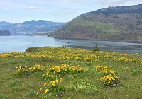 Balsamroot and river view from Mosier Plateau | 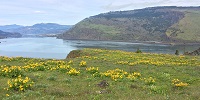 Balsamroot and river view from Mosier Plateau |
If you find this website useful, please consider making a donation to help defray our web hosting costs.
We do not accept any advertising, nor will we ever sell our mailing list. Thanks for your consideration!
'The poetry of the earth is never dead.' -- John Keats